Pin Parvati Trek
The classic Pin Parvati Trek is takes you from Parvati Valley in Kullu district to Pin Valley in Spiti of Himachal Pradesh. Pin Parvati trek is one of the tough treks in Himalayas with lots of challenges and trekking distance of over 100 kms.
Day 1: Manali to Rudranag (7850 feet, 4 km) or Kalga village (7850 feet, 1 km)via Barsheni ( Manali to Barsheni 4 – 5 hours by road, )
Barsheni is the last road-head. Get off here and walk down to Kalga village which is only 30 minutes hike. You can either camp here or hike for another 4 kms to Rudranag. We could not find a safe water source at Kalga so we proceeded for Rudranag . As you get off the road at Barsheni, you can see the confluence of river Parvati (at your right) & River Tos (at your left).
At the left side (below the river) you will see a bridge over River Tos. Cross the bridge and follow the laid trail up the hill going through a couple of local villages. You will pass through some lovely Apple orchards and curious onlookers. The trail now will involve some steep climb for 15 minutes and then will become a gradual level walk. After about an hour into the hike you reach Nakthan Village. You can purchase some last moment supplies here but do not expect much. Rudranag now is only 30 –45 minutes of hike straight ahead the hill with Parvati river below at the right side.
The trail from here has its share of uphill and downhill walks and is manageable. As you reach Rudranag, spot a sacred land with a small temple dedicated to Lord Shiva. Next to the temple is a small waterfall. Locate a suitable spot for camping. Do not use the temple land for camping as it is considered sacred.
Day 2: Rudranag to Khirganga (9192 feet, 3 km, 2 – 3 hours)
Today is relatively easy day for trekking. Proceed ahead from Rudranag on a level-headed trail for 5 minutes till you see a makeshift bridge. Cross the bridge over River Parvati. The trail enters a thick forest cover and involves a steep climb of over 30 minutes. After that spot a couple of water streams running down the mountain on your left. They can be used for filling up your water bottles if needed. There will be 15 minutes of gradual ascent, followed with some level headed trail. You will find a dhaba across a small stream of water where you can enjoy some refreshments or take a breather. You will find yourself again climbing up for another 15 minutes followed with a level-walk of 20 minutes.
The last 40 minutes of the climb is a steep one. This region experiences lot of rainfall so expect the trail to be filled with excess mud on a rainy day. Remain alert as the trail can get slippery at times. The climb continues till you reach a point from where the trail takes a logical U turn and you see a dhaba at your left. From here it is another 5 minutes of walk up to an inclined meadow like setting where Khirganga is located.
You will find lot of make shift huts to accommodate travelers and many restaurants with international cuisines’ on the menu. Locate an empty stretch of land to set up your camp for the night. If it is raining, you can also rent a small room here. Once settled, it is advisable to try out the hot water springs at “Parvati-kund” here. The mobile network that works here are BSNL and Airtel. You will find their network coverage till Khirganga.
Day 3: Khirganga to Tunda-Buj (10952 feet, 12 km, 6 hours)
Today’s trek to Tunda-Buj is a steady ascent out of the gorge below where Parvati River is coming down at your left side. The trail will take you through many pasture land, inside silver birch trees. You will also notice a series of lovely waterfalls on the huge mountain walls in your left side of the trail.
Since the trail is frequently used by Shepherds along their livestock, it remains in bad shape full of mud. You will also find lot of fallen trees on the trail which may slow you down a bit. The trail can be divided into three points for identification and reference-point.
The route from Khir-ganga to the first tributary crossing starts with a steady ascent for about 15 minutes. This is followed with a series of gradual incline and decline. After 45 – 50 minutes, the trail descents towards the stream. You will notice a temporary makeshift bridge over the tributary that you need to cross over. Once you have crossed the stream, climb up to a small open pasture land. From there you will notice the path going inside the forest. With a steady ascent you meander inside the forest for 30 minutes and you will find yourself enter a pasture land. There is a small tent where the locals are selling refreshments. This is the last dhaba on the trail.
The trail curves towards the right and after 20 minutes of hike you will see the second tributary below. Proceed down towards this stream and you have reached the second make-shift bridge. As you cross over, you will see a small pasture land full of knee high bushes and boulders. On your left you will see local shepherds living in their tents. You can buy fresh Buffalo milk from them here at a reasonable rate. Keep walking for 10 minutes straight ahead till you see the trail leading up inside another forest cover. The ascent from here is steep. Watch out for your stepping as it can get slippery with all the mud. After hiking up for 30 minutes you will exit the forest and will see open pasture land and great view of the valley. You have to climb to the top of the hill in the background. Once you reach the top, the trail will swirl inside around the hill and you get to see the vast expanses of the Parvati valley ahead. An abandoned hut can be located on the right side of the trail. From here the trail goes down to the third tributary. This will be the last bridge that you need to cross over and you have reached Tunda-Buj. Look for a suitable spot for camping for the night.
Day 4: Tunda-Buj to Thakur Kuan (11600 feet, 10 km, 4 hours)
Proceed ahead for 30 minutes of level walking on the pasture land. Parvati River will show up at your left side. The terrain is easy and in the distance you will see a Bridge. This wooden bridge is an unstable one but does its job. Cross over this bridge to the other side of the river and take the trail up the mountain. Expect a steep climb of 15 minutes followed with a 1 hour of gradual ascent as you pass through a sloping rocky pasture land.
The Parvati Valley finally reveals itself once you reach the high point. The area has plenty of flowers and in the monsoon season you can expect the whole land in full bloom. Walk down towards the Parvati River at your right for 20 minutes passing through the boulder-strewn fields.
Look out for a pulley bridge used by dam workers here to cross the river. You are advised to carry with yourself a rope and a Carabiner. Keep in mind the load bearing capacity of the pulley bridge as you crossover to the other side. Now the difficult part is taken care of, walk straight up ahead for 30 minutes. You will be able to see a flat meadow ground close to the Parvati river. You have now reached Thakur Kuan.
Day 5: Thakur Kuan to Odi Thach (13 km, 5 – 6 hours)
The terrain from now forth goes through a series of boulder-strewn fields and multiple streams coming down from mountains connecting to Parvati River. Take the logical trail ahead of Thakur Kuan, going through a meadow of flowers for about an hour and half till you reach the river crossing section.
The last 10 minutes to this spot has a series of rock fall sections so tread carefully over the loose sand. Once you have passed this section you will see a large size rock jammed on top of a tributary of Parvati acting as a natural bridge. Climb this Rock and come down to reach to the other side. This rock section can be tricky and slippery so be careful. In a rainy season one can rope the entire team for safety. Now proceed towards doing the same with another Rock acting as a bridge. Cross over this bridge also known as “Pandu-Pull”. Now that the difficult part is taken care off, climb up the hill for about 20 minutes till you reach the level ground leading to Odi-Thach. Notice Mt. Kullu Eiger (5664 Meters) in front of you at the right side along with some un-named peaks and glaciers surrounding the valley. You will also see a series of waterfall in your left-side.
They are the source of water trickling down to Parvati River at your right side. Keep walking straight ahead crossing the boulders and the water streams. After 2 hour of hike, you will reach a level meadow along the river which is Odi Thach.
You can camp here for the night or proceed for another hour and half of gradual incline walk ahead. This campsite is just below the last ridge visible from Odi-Thach. It also has close proximity to the river.
Day 6: Odi Thach to Mantalai (13440 feet, 9 km, 5 hours)
Today’s trek is a gradual walk through boulders, culminating in a plateau with large array of muddy swamp land next to Parvati River. The route towards Mantali swirls towards the right side of the valley.
In the distance you will see a rocky ridge which you will pass after an hour of walking. After crossing this ridge you will see the swamp land along the Parvati river basin. Keep walking in the extreme left side of the valley. After 20 minutes into your hike, you will again be required to climb the second series of moraine ridge. Keep climbing up for about 30 minutes and you will get a large ridge breached from the left side from where River Parvati is rushing down. Mantalai is at the backside of this ridge. Proceed ahead by following the laid out trail in the left side of the valley. Another 3o minute of hike ahead will lead you to the final boulder ridge that needs to be climbed to reach Mantalai region.
There are huge scattered boulders here which needs to be climbed here and will take an hour of climbing. Once you reach the top of the ridge, you get a view of the point from where Parvati river is gushing down. As you walk along the moraine, you get a glimpse of the Mantalai Lake. Climb down the ridge towards the bank of the river where a Lingam of Lord Shiva is placed. From here walk ahead (along the left side of the river bank) till you see a suitable camping spot on a level ground next to the lake. This area is Mantalai.
Day 7: Mantalai to Parvati base camp (15000 feet approx., 12 km, 6 hours)
The most difficult day of the trek, the trail can be tiring with a lot of altitude gain. Proceed ahead with a nice level walk along the river. Then you will encounter a tricky section where one is required to cross the ice cold river crossing on bare foot. After 30 minutes you will reach the base of the mountain from where a steep climb is to be done.
The climb can take anything from 4 to 5 hours to complete. The initial climb will give way to some breathtaking view of the Parvati Valley.
You will also see many endangered species of plants and flowers, especially “Losars” and the “Bramhakamals”. After an hour of gradual ascent, the climb now gets steeper and brutal. Ensure a strong footing as the moraine terrain has loose rocks. You will see a small stream of water nearby flowing down. You have reached the lower base camp and still a lot of distance to be covered. After 2 – 3 hours of more climbing, you reach the point from where you see a visible snowline on the ridge. This is the Parvati base camp site.
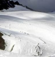
Look for a suitable camping spot but do not expect the luxury of a level ground to set tents on. The snowline leads to the Parvati glacier with its huge ice-fall sections and hidden crevasses.
This will be the final camp site of the trek and the highest point as well. The location of campsite can vary depending on the snow conditions.
Day 8: Parvati base camp to Odi Thach (21 km, 6- 7 hours)
Coming down to Barsheni involves an all descent trail and so one can pace oneself and cover maximum distances to save time. Depending on the weather conditions and the fitness level of the team members, plan your exit from the Valley accordingly. The return trail remains the same one embarked to come up.
Day 9: Odi Thach to Khirganga (32 km, 8-9 hours)
The route involves steep descent as you come down the altitude. A lot of hiking is involved today. It is advisable to break somewhere in between (i.e Thakur Kuan). It is important to mention here that the Indiahikes exploratory team covered this distance due to bad weather conditions in the Valley and torrential downpour making it unsafe to camp in between.
Day 10: Khirganga to Barsheni (7 km, 2-3 hours)
Start early in the morning and reach Barsheni before noon. Take a local bus or a hired cab to Manali.
|
|
Travel Between: September |
||||
| Single Occupancy | Twin Sharing | Extra Adult | Extra Child | Extra Child W/o Bed | |
24500 |
|
||||
DEPARTURES (All departures for The Pin Parvati Trek are ex Manali)
1st Batch : 15th -26th September 2015
2nd Batch : 2nd -13th October 2015
What’s Included :-